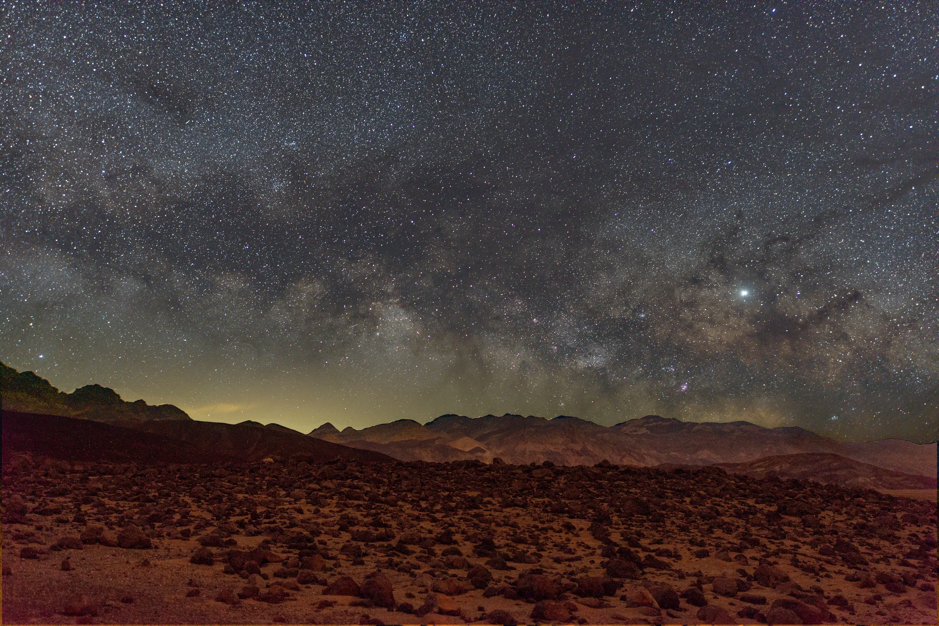
The visitor centre at Furnace Creek sits at 36.5° N, just 1.3° north of my balcony in Nicosia. Every star I can see from Cyprus rises and sets over Death Valley at almost the same altitude, so a trip there buys no new sky. It buys the same sky with the lights switched off. The park covers 3.4 million acres, about 13,800 km², and DarkSky International rates it a Gold Tier Dark Sky Park, its top grade. Winter is the season: long nights, mild days, and a dark-sky festival that lands on the new Moon in February 2027.
This guide covers what the National Park Service’s own sky measurements show, where the light domes of Las Vegas and Pahrump sit from each spot, when to go, and the fees, roads and campgrounds as of early November 2026.
What “Gold Tier” means in numbers
The International Dark-Sky Association (now DarkSky International) and the NPS announced the designation on 20 February 2013. The park’s own release called it the third International Dark Sky Park in the National Park System and the largest. The NPS award page defines the grade in one line: “Gold corresponds to natural, non‐polluted or near‐natural night.” Before the award, the park re-fitted outdoor lights at Furnace Creek and Stovepipe Wells with shielded, downward-pointing fixtures, according to its lightscape page.
To put that in a unit I use, the NPS metrics guide gives 22.0 magnitudes per square arcsecond as the natural reference brightness for a moonless zenith. Sky brightness runs backwards like star magnitudes, so a bigger number means a darker sky, and each magnitude is a factor of 2.5. The same guide puts the brightest natural feature of a moonless sky, the Milky Way, at 19.6.
My best readings in central Troodos are SQM 21.3–21.4, and my balcony manages about 19.0 on a good night. If Death Valley’s dark corners sit close to the natural reference, Troodos is about 1.8 times brighter overhead and my balcony about 16 times. Put another way, my balcony’s background sky at 19.0 is brighter than the Milky Way itself, which is why the Milky Way never shows from home.
Where the glow comes from
The park produces very little light of its own. DarkSky International’s listing puts the problem plainly: “the lights of distant Las Vegas and other cities have an impact on the park’s skies.” The NPS Night Skies Program has photographed it. The panorama below is an all-sky mosaic Dan Duriscoe’s team shot at Racetrack Playa, in the park’s remote northwest, on 18 November 2006, about two hours after local midnight.
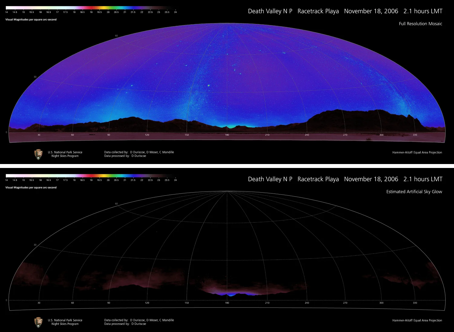
NPS Night Skies Program all-sky brightness mosaic, Racetrack Playa, 18 November 2006. Top: total sky brightness; bottom: estimated artificial glow. Colour scale in visual mag/arcsec². Source: NPS via Wikimedia Commons (public domain).

Most of the top panel falls in the purple-to-blue part of the scale, roughly 21 to 22. The bottom panel strips out the natural light and leaves only the artificial part. It’s confined to a low band hugging the mountains. The brightest patch is due south, the direction of Ridgecrest, about 120 km away, and of the Los Angeles basin, about 300 km out. A weaker band runs through the east-southeast, where Pahrump (about 150 km) and Las Vegas (about 220 km) sit.
That data is nearly 20 years old. Growth in both Nevada towns and the switch to LED street lighting since then could have moved the numbers either way, so read it as the shape of the problem rather than today’s values.
From the busier valley floor, the glow to plan around is east-southeast. I worked out the distances and compass bearings (0° = north, 90° = east) from coordinates:
| Spot | Las Vegas Strip | Pahrump |
|---|---|---|
| Badwater Basin | 144 km, 95° | 70 km, 92° |
| Furnace Creek Visitor Center | 157 km, 104° | 84 km, 109° |
| Harmony Borax Works | 158 km, 105° | 85 km, 111° |
| Mesquite Flat Sand Dunes | 183 km, 107° | 111 km, 113° |
| Mesquite Spring Campground | 218 km, 115° | 149 km, 124° |
From all of these, the city light rises behind the ranges on the valley’s eastern side, which hide the bottom of the dome. For deep-sky work, face west and north. Save the east for the hours after it has climbed. The farther north you go, the farther you are from Las Vegas, which is the case for spending a night at Mesquite Spring near Ubehebe Crater.
Where to set up
The NPS doesn’t publish a stargazing-spot list, but its Dark Sky Festival programme shows where the rangers take people at night:
- Harmony Borax Works, a few minutes north of the visitor centre, hosted the festival’s night-photography meet-up. The interpretive trail is 0.4 km long, partly paved, with sand and broken pavement.
- Mesquite Flat Sand Dunes, near Stovepipe Wells, is the other photography site. You can see the dunes from the car park, but walking into them means deep sand.
- Furnace Creek’s small airport is where the Las Vegas Astronomical Society sets up telescopes for the festival star party.
- Badwater Basin, 86 m below sea level, gives you a salt-flat horizon in every direction except where the mountains rise. The NPS warns about holes in the salt crust, so walk out before dark and memorise the route back.
- Zabriskie Point hosted an evening talk and has a paved but steep path up to the viewpoint.
The Inyo County visitor bureau passes on the park’s tagline, “Half the Park is After Dark,” and says ranger night-sky programmes run in season, November to April. Check the park calendar when you arrive.
Give your eyes the full 30 minutes of dark adaptation before you judge the sky, and keep the red torch dim. Under a sky this dark, one white phone screen undoes most of it.
When to go
Summer nights in the valley are short and hot. Winter fixes both. I ran the Sun’s position for Furnace Creek: astronomical darkness, with the Sun more than 18° below the horizon, lasts 11.2 hours around the December and January new Moons (18:05 to 05:17 Pacific Standard Time on 9 December) and still 10.5 hours on 6 February.
The NPS weather page gives these Furnace Creek averages from park and National Weather Service records, 1911–2007:
| December | January | February | |
|---|---|---|---|
| Average high | 18 °C | 19 °C | 23 °C |
| Average low | 3 °C | 4 °C | 8 °C |
| Average precipitation | 5 mm | 7 mm | 9 mm |
The record low there is −9 °C. Temperatures fall 2–3 °C for every 300 m you climb, so a night at higher campgrounds runs colder than the valley figures. The page also notes that winter storms can bring cloud and rain, and that dust storms “can suddenly blow up with approaching cold fronts”, which is what happens to transparency in Cyprus when the Saharan dust arrives.
Then plan around the Moon. The lunar cycle gives you about a week of good nights either side of each new Moon. The next four, from the US Naval Observatory:
- 9 December 2026, 00:52 UTC (16:52 PST on 8 December)
- 7 January 2027, 20:24 UTC
- 6 February 2027, 15:56 UTC
- 8 March 2027, 09:29 UTC
Two things on that calendar I’d plan around. The Geminids peak on the night of 13–14 December, and on 13 December the Moon is a 19% crescent that sets at 20:50 PST over Furnace Creek, leaving the rest of the night dark while the Gemini radiant climbs. February suits the gegenschein, the faint oval glow of sunlight reflected by interplanetary dust at the point directly opposite the Sun. On 6 February that point sits at ecliptic longitude 137°, near the Cancer–Leo border and well clear of the Milky Way. In mid-December it falls in Taurus–Gemini, inside the winter Milky Way, where it’s much harder to separate. The same February evenings put the zodiacal light up in the west after dusk.
The winter sky itself is the Orion side of the Milky Way. If you’ve found the Orion Nebula from a city, see how much of the surrounding nebulosity shows up here with the naked eye. A Pleiades star count is a quick way to compare the sky with home.
The Dark Sky Festival, 5–7 February 2027
The park’s festival page lists the next edition for 5–7 February 2027, which brackets the 6 February new Moon. Partners are NASA’s Goddard Space Flight Center, the Jet Propulsion Laboratory and Ames Research Center, the Las Vegas Astronomical Society, the SETI Institute and Caltech.
The 2027 schedule isn’t up yet. The February 2026 edition ran science talks at the Furnace Creek Visitor Center, a drop-in telescope star party at Furnace Creek Airport from 19:00 to 22:00 with ranger constellation tours, and night-photography meet-ups at the Mesquite dunes and Harmony Borax Works. Daytime field walks covered Ubehebe Crater and the Mars-analogue terrain used during design work for NASA’s Viking landers. Evening keynote tickets had to be collected at the visitor centre the day before. Expect in-park lodging for that weekend to go early.
Getting there, fees and where to sleep
Most people fly into Las Vegas. The NPS FAQ puts the fastest route to Furnace Creek, via Pahrump, at about 190 km and two hours, while the park’s lodging page says two and a half. That road takes you straight through the Pahrump light dome, so don’t judge the sky on the drive in.
Entrance, from the fees page, updated 1 January 2026:
- $30 per private vehicle, valid for 7 days with unlimited re-entry. The park takes cards only, no cash, and no entry reservation is needed.
- The America the Beautiful annual pass is $80 for US residents and $250 for non-US residents. For a European visiting one park, the $30 weekly pass is the obvious buy.
The lodging page lists three in-park options, all open all year: Stovepipe Wells Village, The Oasis at Death Valley at Furnace Creek (the Inn and the Ranch), and Panamint Springs Resort. For camping, the park’s guide says Furnace Creek takes reservations for 15 October to 15 April on recreation.gov up to six months ahead and is booked to capacity most days. The others are first-come, first-served. Sunset Campground “almost always has sites available, even in peak season,” and generators are banned at Texas Springs, which keeps it quiet.
Check current conditions right before you go. The update of 3 November 2026 had:
- Texas Springs and Sunset still on seasonal closure. Furnace Creek, Stovepipe Wells, Mesquite Spring and Wildrose were open, with no water at Wildrose.
- Scotty’s Castle and Bonnie Claire Road closed with no reopening date, and Titus Canyon Road closed until an expected May 2027.
- Debris on the North Highway after flooding on 1 November.
- Scheduled power-maintenance outages through 20 December that can knock out cell signal.
What I’d do
My version of this trip is the festival weekend for the talks and the star party, then two nights at Mesquite Spring, as far from Las Vegas as the paved roads go. I’d take a tripod and a wide lens for fixed-tripod frames of the winter Milky Way, binoculars, and my SQM, because the Racetrack mosaic is from 2006 and I’d like a 2027 number to put next to the Troodos readings.